Sunday, February 27, 2011

Deserts and Convectional Precipitation

Deserts
A desert is a piece of land that has small amounts of precipitation throughout the year, no matter how hot of cold. It usually has less than 10 inches (25cm) of rainfall per year.
The deserts cluster along 30 degrees latitude North and South (i.e. Tropic of Cancer and Tropic of Capricorn).
deserts
Distribution of deserts on the globe
Convectional Precipitation


Convectional precipitation is a type of rain that is formed due to the uplifting of a heated air mass in the atmosphere.

It occurs when there is intense and uneven heating of the Earth's surface, which usually takes place in the morning and early afternoon, where heat from the Sun is strong. When air above the ground is heated intensely, it will rise quickly. The colder air will rush in to take its place. 

As the warm air rises, it cools adiabatically*. The temperature of the rising air decreases as it rises, until it reaches the saturation point**, at which relative humidity is 100%. At this point, condensation occurs and clouds form. When the water droplets get too big and heavy, precipitation will occur. This process is known as convectional precipitation.

*Adiabatic Principle: Physical principle that a gas cools as it expands, warms as it compresses
Change in temperature caused only by pressure change
**Saturation point: Also known as dew point, in our book


Convectional Precipitation (class)
From this picture, the urban land gets heated up faster than the vegetation because concrete (metal) absorbs heats faster. As warm air rises from the urban land, it is cooled adiabetically, and clouds are formed. The cooler air from the vegetation flows to the urban land. However, it is incorrect that the clouds move towards the vegetation and precipitation occurs above the vegetation (as shown from the arrows). If this were true, then the urban land will not receive rain! Instead, precipitation will fall on both urban land and the vegetation.

Why is Convectional Precipitation common in Singapore?
Singapore is a tropical country. The high temperatures experienced in tropical regions increases the capacity of the air to hold large amounts of water vapour. Therefore, convectional rain is common in tropical regions because relative humidity is high in the Tropics. (When humidity is very high, more water vapour will condense into clouds, resulting in a dense mass of clouds)

Ng Jane Wen, Chelsia
JH402/ (8)

Saturday, February 26, 2011

More information about the Equinoxes


 The name "equinox" is derived from the Latin aequus (equal) and nox (night). Find out why below.


An equinox occurs  when the tilt of the Earth's axis makes a right angle with the Sun's rays.
 Because of this,  equal latitudes to the North and South of the Equator (eg. 10 degrees and -10 degrees) experience equal spread of solar energy and consequently, nights of equal length. About the equator, the length of night and day will be about 12 hrs each. However, this is not true throughout the globe due to difference in latitude. Also, the word 'equinox' denotes a moment in time and not a whole day or two.  A day in which day and night are closest to being 12hrs each is referred to as equilux.
There are 2 equinoxes a year, one in March and one  in September. They are respectively referred to as the Vernal or Spring Equinox and Autumnal Equinox in the Northern hemisphere. The words can be reversed on the other hemisphere as spring and autumn occur at opposite times in the different hemispheres. 

One important thing to remember is that the Equinox denotes the first day of that season. The Autumnal Equinox, for example, is the first day of autumn. Same goes for spring. 


The above plots show how the date of the autumnal equinox shifts through the Gregorian calendar due to the fact that one year is not exactly 365 days. It is roughtly 365.25 days long. The .25 is made up after four years by the Leap Year, which has an extra day. As a result, the specific date and time of the equinoxes migrate through a period that occurs about six hours later from year to year.

The system resets every leap year, slipping a little bit backward until a non-leap century year nudges the equinoxes forward in time once again.


(a century year is a year that is exactly divisible by 400. Eg, 2000. A non-leap century year is a century year that is not a leap year)

When the Sun passes the autumnal equinox, nights begin to grow longer than days, and continue to do so until the Winter Solstice. Conversely, when the sun passes the vernal equinox, days continue to grow longer until the Summer Solstice.


The table below gives the universal time of the autumnal equinox.  (In the southern hemisphere, this situation is reversed).


yearEquinox
Mar
Solstice
June
Equinox
Sept
Solstice
Dec
daytimedaytimedaytimedaytime
20042006:492100:572216:302112:42
20052012:332106:462222:232118:35
20062018:262112:262304:032200:22
20072100:072118:062309:512206:08
20082005:482023:592215:442112:04
20092011:442105:452221:182117:47
20102017:322111:282303:092123:38
20112023:212117:162309:042205:30


The autumnal equinox for year 2011 has been calculated to be on September 23rd, 9:04 AM.


Interesting facts on the perception of the Equinox:


  • Day and night would each be exactly 12 hours long on a spring or fall equinox only if the sun were a single point of light and Earth had no atmosphere.
  • The true days of day-night equality always fall after the autumnal equinox and before the vernal, or spring, equinox, according to Geoff Chester, a public affairs specialist with the U.S. Naval Observatory in Washington, D.C.
  • The equinoxes are also the only days of the year when a person standing on the Equator can see the sun passing directly overhead.
  • On the Northern Hemisphere's autumnal equinox day, a person at the North Pole would see the sun skimming across the horizon, signaling the start of six months of darkness. 
  • On the same day, a person at the South Pole would also see the sun skim the horizon, beginning six months of uninterrupted daylight.
  • These two effects are caused by the sun's heat only hitting the earth's surface that faces the sun and not the poles (see below)
  • If the earth had no tilt, we would technically be experiencing a perennial equinox.
  • Equinoxes are celebrated in many cultures, for example Japan, where Vernal Equinox day is a national holiday where ancestral graves are worshipped. In Arab countries, Mother's Day is celebrated on the March equinox. In India, Tamil and Bengali New Years are celebrated according to the Vernal Equinox. In Korea, Chuseok is a major harvest festival that occurs during the Autumn Equinox where three days of public celebrations are held.
  • All these examples show us that the equinoxes do, in fact, affect the lives of people and are not just purely astronomical happenings that pass by without people noticing them. 

PS. Ever had one of those annoying 'we cannot show any TV due to satellite interference caused by solar outage' on Starhub Cable TV?

One effect of equinoctial periods is the temporary disruption of communications satellites. For all geostationary satellites, there are a few days around the equinox when the sun goes directly behind the satellite relative to Earth for a short period each day. The Sun's immense power and broad radiation spectrum overload the Earth station's reception circuits with noise and, depending on antenna size and other factors, temporarily disrupt or degrade the circuit. The duration of those effects varies but can range from a few minutes to an hour. 

Posted by Shu En, Sat Feb 26


Friday, February 25, 2011

Uneven Heat Distribution and the Planetary Heat Balance

What is Latitude?

  • Latitude lines are horizontal lines running across the earth. They measure the distance of a location from the equator. Latitude is measured by the angle from the centre of the earth to the location you are measuring. That is why the equator is called 0 degrees.
Fig 1: Latitudes

Here is the trend of uneven heat distribution. Try superimposing the latitude lines onto the picture.


Fig 2: Uneven Heat Distribution
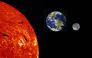
Here is a picture of the Earth and the Sun.

Fig 3: Earth and Sun

Clearly, something happens as the sun's rays hit the earth that causes some regions to be hotter than others. That process is best represented through shortwave and longwave radiation. As we know, shortwave radiation is absorbed by the atmosphere and the earth's surface. Some of it is reflected back into space. The radiation that is not reflected back, that is, the radiation that stays in the Earth's system, is converted into longwave radiation and circulates as heat in the Earth.Eventually, the system is completed when the same amount of heat that was added into the Earth by the sun is released into space by the Earth.

We know that areas where latitude is farther from the equator experience less heat from the sun. This is shown through a diagram in our booklet:


This then shows us that areas which are closer to the sun receive more shortwave radiation. As more shortwave radiation is then converted into longwave radiation in the atmosphere over that particular location, there is greater greenhouse effect. Greater input and output means greater heat running through the system at any one time. This contributes to high temperatures near the equator. 

The absorption of the sun's shortwave radiation can be further broken down into its component parts. Areas near the equator that have high humidity, such as Singapore, absorb more shortwave radiation through clouds and aerosols (water vapour). There is also more conduction, convection and condensation going on as water rises into the Earth's atmosphere, which contributes to the units of energy released into the atmosphere as sensible heat and latent heat. All this adds up to greater greenhouse effect. This may be why we have higher temperatures than our neighbour Malaysia despite being around the same latitude. However, why does Singapore, which clearly absorbs a lot of shortwave radiation, have lower temperatures than some areas in Africa, even though they are much farther north of the Equator than us?

Turns out that climate is based on many more factors than latitude. Singapore is near the ocean, which acts as a heat sink. Our temperatures experience very little fluctuation because of the higher heat retaining properties of water. Water has higher heat capacity than land, thus when it is hot our land temperatures are lowered by the water. When it is colder our land temperatures are warmed by the water. 

Also, the winds circulating around Singapore are primarily trade winds. The two trade winds from the northern and southern hemisphere meet at the equator (ie. where Singapore is.) When the winds meet, it causes the air to rise. As the air enters the higher end of the troposphere it condenses causing clouds and rain. Rain cools the surface, lowering temperatures. Clouds have a fairly strong albedo effect, reducing the radiation absorbed into the atmosphere.


Africa is a semi-arid country, with a great expanse of inland where there are no coastal areas to absorb the heat from the sun. The hottest countries in Africa are clustered around the Tropic of Cancer, roughly 23 degrees latitude, which t receives direct, concentrated sunlight for a quarter of a year. However, there are also areas in Africa near the sea where it is very, very hot. This can be explained via wind patterns.


Both westerlies and trade winds blow away from the 30 ° latitude belt. Over large areas centered at 30 ° latitude, surface winds are light. Air slowly descends to replace the air that blows away. Any moisture the air contains evaporates in the intense heat, thus it is very hot and dry. The tropical deserts, such as the Sahara of Africa, exist under these regions.


I also feel that because Africa has little clouds and aerosols, more radiation is absorbed directly at the surface as opposed to by clouds and aerosols. There is also absence of albedo effect that would reflect radiation back into space thus the land really gets the full extent of shortwave radiation. Thus in Africa, more heat is felt closer to the Earth's surface leading to high temperatures.


More info on Climates:

The Köppen system recognizes five major climate types based on the annual and monthly averages of temperature and precipitation. Each type is designated by a capital letter.

A - Moist Tropical Climates are known for their high temperatures year round and for their large amount of year round rain.

Clearly, this refers to Singapore.
B - Dry Climates are characterized by little rain and a huge daily temperature range. Two subgroups, S - semiarid or steppe, and W - arid or desert, are used within the Bclimates.
Deserts fall under this category. Africa is semi-arid as mentioned above. The Sahara desert is arid.
C - In Humid Middle Latitude Climates land/water differences play a large part. These climates have warm,dry summers and cool, wet winters.
Los Angeles in the US is on example.
D - Continental Climates can be found in the interior regions of large land masses. Total precipitation is not very high and seasonal temperatures vary widely.
 Yakutsk, Russia is an example of this. The climograph can be found in our book.
E - Cold Climates describe this climate type perfectly. These climates are part of areas where permanent ice and tundra are always present. Only about four months of the year have above freezing temperatures.
Greenland, for example.


It's kind of interesting to see that we have such a huge variation of climates in the world. It truly creates much diversity of life. 


N.B.

 If you live north of the Tropic of Cancer or south of the Tropic of Capricorn, you do not receive direct sunlight at any point in the year. This explains the sudden drop in temperatures on the Earth's surface.

 (Observe the sharp drop from orange to yellow with hardly any intermediate temperatures.)

Posted by: Lee Shu En
Sat 26 Feb

Monday, February 21, 2011

EARTH AND SYSTEMS - IT'S ALL INTERCONNECTED

DEFINITION 
A set or assemblage of things connected, associated, or interdependent, so as to form a complex unity; a whole composed of parts in orderly arrangement according to some scheme or plan.                                                                     - Oxford English Dictionary
The Earth system is composed of interacting physical, chemical, and biological processes that move and change materials and energy on Earth. The system provides the conditions necessary for life.
For example, plants, which are part of the living system, use light energy to change carbon dioxide into organic carbon. Less carbon dioxide in the atmosphere helps to cool Earth. Winds and ocean currents move heat from the tropics to higher latitudes, helping to warm the higher latitudes. 


These interconnections are not in a linear motion where it leads from one process to another process systematically. However, if we look at the big picture, we can see that they are connected and interdependent on many other things. (Let's just say that if we were to include everything, it would look very complicated because of numerous arrows).


CARBON CYCLE AND NITROGEN CYCLE


SUN'S EFFECT ON EARTH

The Sun warms our planet, heating the surfaec, oceans and atmosphere. This energy transferred to the atmosphere drives our weather (found in Stratosphere). Our climate is also strongly affected by the amount of solar radiation received at Earth. This is based on the Earth's albedo.


CLIMATE AND GLOBAL CHANGE

Earth is warm near the equator and cold at the poles, thus it can support a variety of living things because of its diverse regional climates. The avergae of these regions make up Earth's global climate. Climate has cooled and warmed throughout Earth's history for many reasons. The scientific reason is due to the addition of heat-trapping greenhouse gases which are increasing dramatically in the atmosphere as a result of human activities.

Human activities such as Industrial plants, power plants and vehicles with internal combustion engines produce nitrogen oxides, carbon monoxide, carbon dioxide and sulfur dioxide. Some of these gases are greenhouses gases, meaning that they retain heat in the Earth's atmosphere.

Permafrost is ground that is below the freezing point of water (0°C or 32°F) for two or more years. It is found at high latitudes like the Artic and Antartic. It is also common at high altitudes - like mountainous areas. Permafrost has been thawing relatively quickly in recent years. Scientists have found that the rate of permafrost thaw has increased because of global warming.


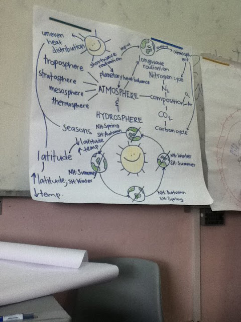
I think Azirah's group gave a very good mindmap so i took a picture.


RESOURCES


Posted by : Jaspreet Kaur